


Tour de Florac

cordierlavenant
User
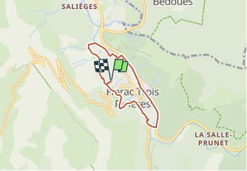

Length
5.7 km

Max alt
589 m

Uphill gradient
93 m
Km-Effort
6.9 km

Min alt
537 m

Downhill gradient
93 m
Boucle
Yes
Creation date :
2023-12-05 09:08:17.174
Updated on :
2023-12-05 10:20:40.361
1h12
Difficulty : Very easy

FREE GPS app for hiking
 SityTrail
IGN / Geographical institutes
SityTrail Plus
The world is yours!
About
Trail Walking of 5.7 km to be discovered at Occitania, Lozère, Florac Trois Rivières. This trail is proposed by cordierlavenant.
Positioning
Country:
France
Region :
Occitania
Department/Province :
Lozère
Municipality :
Florac Trois Rivières
Location:
Florac
Start:(Dec)
Start:(UTM)
546944 ; 4908348 (31T) N.
Comments